Follow this arrow.

Thanks to Steve Zimmer and other BRATTS volunteers who placed
115 of these markers along the Belknap Range Trail – July 4, 2014
Click to download trail description.
Trail Name: Belknap Range Trail
Gilford, Gilmanton, Alton NH.
Trail Description: Updated by Weldon Bosworth and Hal Graham from Southern New Hampshire Trail Guide. 3rd Edition. 2010. Compiled and Edited by Gene Daniell and Steven D. Smith. Appalachian Mountain Club Books. Boston, MA.
_______________________________________________________________________________________________
Belknap Range Trail – Description
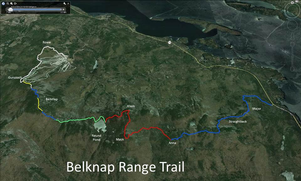
This Belknap Range Trail extends from the Gunstock Mountain Resort to Mt. Major parking area using all or part of several other trails along the way. Sections of this trail have existed in some form for a number of years, but only recently has it been possible for the average hiker to have any hope of following large segments of this route. Much of the trail between the Gunstock Mountain Resort and Mt.Anna is easy to follow, and the rest requires only reasonable care. Between Mt.Anna and Mt.Major following some parts of this trail requires a substantial amount of care, though the situation has improved in recent years.
Following the classical Belknap Range Trail route the hiker will traverse the summits of Mt. Rowe (1680’), Gunstock Mtn. (2245’), Belknap Mtn. (2382’), Mt. Klem (2001’), Mt. Mack (1945’), Mt. Anna (1670’), Straightback Mtn. (1890’), and Mt. Major (1786’). These are eight out of the twelve Belknap Range Peaks required to earn the Belknap County Sportsmen’s Association’s Belknap Range Hiker patch (see http://www.belknapsportsmensclub.com/hiking.html). The total mileage following the classical route is 12.2 mi. An alternative, more scenic but somewhat more demanding route, is also included at the end of this trail description. This alternate route traverses Mt. Rand (1833’), West Quarry Mtn. (1894’), and East Quarry Mtn. (1890’) rather than Mt. Mack and Mt. Anna. The total mileage following this alternate route is also 12.2 mi. or slightly less if one takes the Quarry Spur Trail from North Straightback to Mt. Major.
The Belknap Range Trail leaves the Gunstock Mountain Resort main parking lot and follows the Ridge Trail (blazed white) over Mt. Rowe to the summit of Gunstock Mtn. at 2.4 mi. It then descends on the Brook Trail (blazed yellow) and Saddle Trail (blazed white) to the Belknap-Gunstock col at 2.8 mi., and follows the Blue Trail (blazed blue) to the summit of Belknap Mtn. at 3.3 mi. It then descends on the East Gilford Trail (blazed yellow) and then the Boulder Trail (blazed blue), becoming quite steep until it reaches the sag where the Round Pond – Piper Link Trail (blazed green) enters on the right at 4.1 mi. From here, the Belknap Range Trail, coincides with the Round Pond-Piper Link Trail. It climbs over several small humps and through the sags between them, then climbs with two short steep pitches up a larger hump. It then runs along the north side of the ridge with minor ups and downs, and meets the red-blazed Round Pond Trail coming up from the left (north) at 4.9 mi. It turns right on this trail, and descends with the Round Pond Trail gradually 0.1 mi. to a secluded spot at the shore of Round Pond. From here the Belknap Range Trail follows the Round Pond- Piper Link Trail along the northwest shore of Round Pond and then climbs briefly to the Round Pond Woods Road at 5.2 mi. (This former access from Grant Rd. has been closed at its lower end). The Round Pond-Piper Link Trail continues for about 0.2 mi. to the trailhead of the Mount Klem – Mt. Mack Loop (at 5.4 mi.). This junction is marked by two red wooden diamonds and a sign, “KLEM.” The diamonds are facing toward a westbound hiker; eastbound, the trail diverges on the left just after the woods road begins to climb away from the edge of the pond.
The Belknap Range Trail now turns left following the Mount Klem–Mt. Mack Loop. Leaving the shore of Round Pond, the trail climbs steadily through a dense coniferous forest, then levels and passes through a small sag. It climbs more easily, passing a view of Belknap Mtn. at 5.7 mi., crosses a stone wall, and ascends to a ledgy area. Here it swings left, descending slightly, then ascends across another ledgy outcrop. It dips through a shallow sag and runs on contour as it curls around the north end of Mt. Klem somewhat below the true summit at 6.0 mi. At 6.2 mi. it passes a beautiful outlook to the northeast and swings right, then runs almost level for some distance, passing a junction with the white-blazed Dave Roberts’ Quarry Trail (sign) on the left at 6.3 mi. At this junction, the Mt. Klem summit is to the right (west) about 100 yds. on a poorly-marked trail. (Alternative Route Begins Here). Finally the trail begins to descend and crosses an open area with views southeast at 6.4 mi. It descends across another ledgy spot with a view into a sag at 6.7 mi., then climbs up to a rocky knob, crosses a small dip, and climbs to its southeastern junction with the Belknap Range Trail near the summit of Mt.Mack.
At the summit of Mt. Mack the Belknap Range Trail turns left east towards Mt. Anna (sign) but soon swings back to the left and descends at easy to moderate grades. In all it descends over 500 ft.-the last part with several minor ups and downs-until it reaches its low point at a mossy brook at 7.7 mi. It begins to climb a bit, crossing a stone wall that is the Gilford -Gilmanton town line, and then climbs more seriously, although descending briefly at one point to cross a brook, to the flat ledgy summit of Mt. Anna, where views are restricted. At 8.4 mi., in the flat summit area a trail jct. is reached; the trails to the right and straight ahead descend toward Hidden Valley, while the Belknap Range Trail turns left and starts a mild descent.
At 8.5 mi. the trail reaches the top of a short steep, rocky pitch, then makes numerous small ascents and descents with occasional slightly obscure places. At 9.1 mi. it bears left at a small rock face, and at 9.3 mi. it enters an open ledgy area with views ahead to part of Straightback Mtn. and, higher up, back to Belknap Mtn. The general route across this area is obvious, but it is poorly marked; there is little problem in clear weather, but in fog it could be very difficult to cross this area correctly without following a compass course. The trail climbs past a junction with the Quarry Trail on the left at 9.5 mi., and reaches a point just north of the south summit of Straightback Mtn. at 9.6 mi., where it turns sharp left. The various ledges and open areas of this summit repay exploration; an obscure trail continues ahead (east) across the ledges, eventually descending the southeast side of the mountain. The main trail now descends, mostly in the woods, often angling to the left, passing a junction with the Quarry Spur Trail, a branch of the Quarry Trail, on the left at 9.7 mi. At 9.8 mi. it crosses a ledge with a glimpse of Lake Winnipesaukee, then descends again to the col between Straightback Mtn. and Mt. Major, reaching a trail junction just on the Mt. Major side of the col at 10.2 mi. The path on the left here is the yellow-blazed Brook Trail, which descends to the parking lot on NH 11 in 1.9 mi. The Belknap Range Trail, now coinciding with the Brook Trail and blazed in blue and yellow, ascends the ridge, soon coming into the open, passing a junction on the right with the Jesus Valley-Beaver Pond Trail at 10.5 mi., and following a fairly obvious route up to the summit of Mt. Major at 10.7 mi., where there are magnificent views and the remains of a stone hut. (Click here to find out how Mr. Phippen’s Hut got here). From the summit of Mt. Major follow the blue blazes northeast directly down the ledges towards the southern part of Lake Winnipesaukee, reaching the Mt. Major parking area at 12.2 mi.
Distances from Gunstock Mountain Resort parking area (930 ft.):
- to summit of GunstockMtn. (2,250 ft.): 2.8 mi.(4.5 km.), 1,500 ft. (rev. 250 ft.), 2 hr. 10 min.
- to summit of BelknapMtn. (2,382 ft.): 3.6 mi. (5.8 km.), 1,900 ft. (rev. 250 ft.), 2 hr. 45 min.
- to Round Pond Trail junction (1,710 ft.): 5.4 mi. (8.7 km.), 2,200 ft. (rev. 1050 ft.), 3 hr. 50 min.
- to summit of Mt.Mack (1,945 ft.): 7.3 mi. (11.7), 2,750 ft. (rev. 250 ft.), 5 hr.
- to summit of Mt.Anna (1 ,670 ft.): 8.7 mi. (14.0 km.), 3,250 ft. (rev. 750 ft.), 6 hr.
- to high point on Straightback Mtn. (1,880 ft.): 9.9 mi. (15.9 km.), 3,650 ft. (rev. 200 ft.), 6 hr. 45 min.
- to summit of Mt.Major (1,786 ft.): 11.0 mi. (17.7 km.), 3,850 ft. (rev. 300 ft.), 7 hr. 25 min.
- to Mt. Major parking area (650 ft.): 12.5 mi. (20.1 km.) 3850 ft. (rev1150 ft.), 8 hr. 10 min.
Alternative Route starting from Mt. Klem
From the junction of Dave Roberts’ Quarry Trail, turn left towards Mt. Rand and follow the Dave Roberts’ Quarry Trail description in reverse to the south summit of Straightback Mtn.
From junction at Mt. Klem:
- to Mt. Rand (1883 ft.): 0.6 mi. (1.0 km.), 200 ft., 30 min.
- to West Quarry Mtn. summit (1894 ft.): 1.6 mi. (2.6 km.), 300 ft., 1 hr. 5 min.
- to East Quarry Mtn. ((1890 ft.): 2.2 mi. (3.5 km.), 100 ft., 1 hr. 30 min.
- to south summit of Straightback Mtn. (1830 ft.): 3.3 mi. (5.3 km.); 200 ft., 2 hr. 10 min.