Click here to download trail descriptions.
Trail Name: Mt. Major Trail (aka Blue Trail)
Alton, NH
Trail Description: Southern New Hampshire Trail Guide. 3rd Edition. 2010. Compiled and Edited by Gene Daniell and Steven D. Smith. Appalachian Mountain Club Books. Boston MA.
_______________________________________________________________________________________________
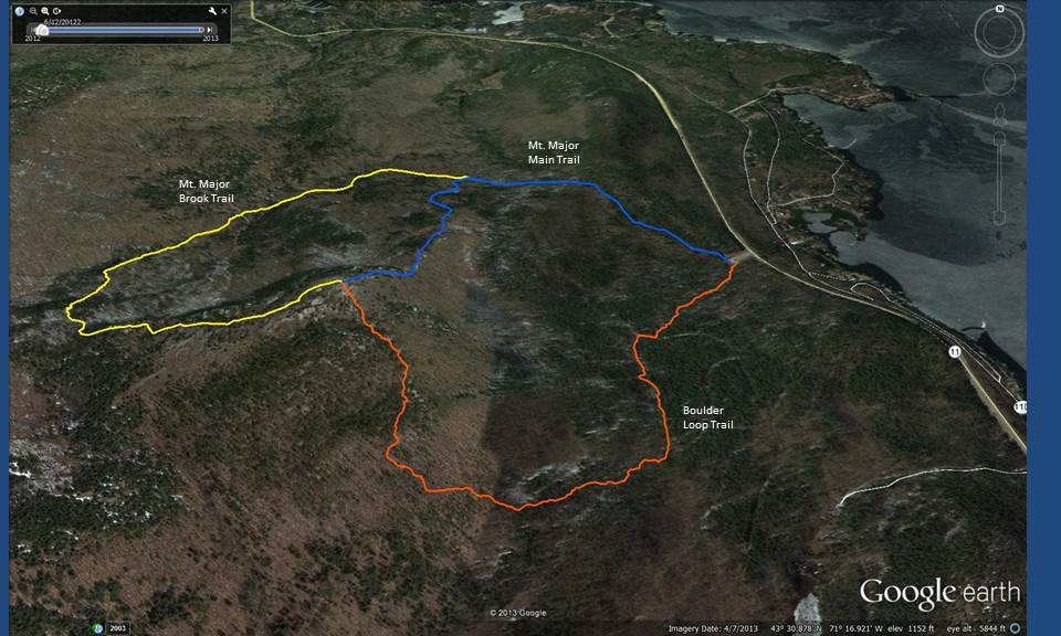
Mt. Major Trail – Description
The Mt. Major Trail, well-blazed in blue, begins at a parking area on NH11, 4.2 mi. north of Alton Bay and 2.4 mi. south of the jct. of NH11 with NH l1A. This is also the eastern terminus of the Belknap Range Trail. The trail leaves the right side of the parking area and follows a lumber road west, ascending a steep, severely eroded section where several alternate roads diverge and rejoin; the road farthest to the right (ascending) offers slightly better footing than the others. At the top of this steep section, at 0.3 mi., the road becomes nearly level and smooth. At 0.7 mi. the Mt. Major Trail diverges sharply left on a path as the Brook Trail continues ahead. The Mt. Major Trail climbs steeply through second growth and over ledges, with some steep scrambles near the top. At 1.3 mi. there are two alternate routes, both signed and blazed in blue: the “Main Trail via ledges” route forks to the right and climbs up steep ledges (potentially dangerous when wet or icy), while the “Main Trail-ledge detour” diverges left, avoiding the steepest scrambles, The two routes rejoin at 1.4 mi.; various other unofficial routes in this area have been closed off as revegetation areas. The summit, with the ruins of a stone hut (” Mr. Phippin’s Hut” ) is reached at 1.5 mi. For the descent from the summit via the Mount Major Trail, follow the blue blazes northeast directly down the ledges towards the southern part of Lake Winnipesaukee. For descent via the alternate route (Brook Trail), walk southwest down the ledges towards StraightbackMtn., following the blue and yellow blazes. At 0.5 mi. from the summit turn right onto the yellow-blazed Brook Trail (sign).
Distances from NH 11 (650 ft.):
- to Mt.Major summit (1,786 ft .) via Mount Major Trail: 1.5 mi. (2.4 km), 1,150 ft ., 1 hr. 20 min.
- to Mt.Major summit (1,786 ft .) via Mount Major Trail, and Brook Trail: 2.4 mi. (3.9 km) , 1,150 ft., 1 hr. 45 min.
- to starting point via complete loop: 3.9 mi. (6.3 km.), 1,150 ft., 2 hr. 30 min
Trail Name: Brook Trail
Alton, NH
Trail Description: Alan Sherwood
_______________________________________________________________________________________________
Brook Trail – Description
The Brook Trail (blazed yellow) begins at the junction where the Blue Trail (aka Mt. Major Trail and Belknap Range Trail) turns left (elev. 925 ft). From this junction continue west by northwesterly on the flat Brook Trail. In a short distance there is an old stone cellar hole on the right. At a low point at 0.2 mi. the trail turns left and runs southwesterly to climb gradually, generally following the brook. A short distance after the left turn a red blaze is located about where the Rock Cave trail starts on left. At about 0.5 mi. reach the first of two brook crossings. At both crossings in higher water some very creative rock hopping is required to keep your feet dry. From here on the grade alternates between easy and moderate. It recrosses the brook at 0.7 mi. and ascends alongside it, with loose footing on some severely eroded sections (some of which have been bypassed). At 0.9 mi. it swings left away from the edge of the valley where green-blazed North Sriaghtback Link continues ahead.
The Brook trail continues south by southeast to intersect with the Blue Trail (Belknap Range Trail) at 1.2 mi. (Sign on tree: “Left Mt Major 0.4 mi., Right Mt. Straightback – 0.7 mi., return to parking lot 2.0 miles”. The Brook trail turns left, easterly (blazed yellow and blue here). In a short distance there is an open view to the north and then a jog to the right and back into the trees for the next 0.1 mi. Then views open sporadically to the north, west and south; gradually being more open. At about 1.5 mi. there is an intersection on right with a multiple use trail. This is the Jesus Valley – Beaver Pond Trail partially maintained by the Mt. Major Snowmobile Club. The Jesus Valley Trail – Beaver Pond Loop Trail drops down southeasterly to meet snowmobile Trail D at the Old Stage Road; a few hundred feet west of Jesus Valley Road.
At 1.5 mi. the combined yellow/blue-blazed trail turns northeasterly and in the last 0.1 mi. views open up. Reach Mt Major summit at mile 1.7. Enjoy spectacular views of Lake Winnipesaukee to the east and north.
Hiking time and distance from Blue Trail junction (925 ft.):
- to Mt.Major summit (1,786 ft.): 1.7 mi. (2.6 km.), 850 ft., 1 hr.25 min.
Trail Name: Boulder Loop Trail
Alton, NH
Trail Description: Southern New Hampshire Trail Guide. 3rd Edition. 2010. Compiled and Edited by Gene Daniell and Steven D. Smith. Appalachian Mountain Club Books. Boston MA.
_______________________________________________________________________________________________
Boulder Loop Trail – Description
The Boulder Loop Trail (blazed orange) provides an attractive route up the south side of the Mt.Major from the trailhead parking area on NH 11. The lower section follows a snowmobile trail that leaves the left side of the parking area (sign: Boulder Loop Trail), crosses two plank bridges, and in 30 yd. turns right up a bank past a boulder where a woods road continues ahead. It climbs moderately up a woods road also used as a snowmobile trail to a T-jct. at 0.4 mi., where the Jesus Valley-Beaver Pond Trail diverges left. Here the Boulder Loop Trail turns right, then in 40 yd. bears left at a fork, and ascends south along the woods road. At 0.7 mi., where the road becomes wet and curves to the left, the trail continues ahead into the woods on a footpath.
It ascends steadily through an area strewn with boulders, swings right (west) at 1.0 mi., squeezes between and under boulders at 1.2 mi., then climbs a steep, gravelly pitch. At the top of the pitch it turns right, then left and runs at easy grades through pine and oak woods, then ascends gradually over open ledges, with increasing views east and south, to the summit. To descend by this trail, walk south across the ledges from the hut and look for orange blazes on the rock.
Distance from Mt. Major Parking lot (650 ft.):
- to Mt.Major summit (1,786 ft .): 1.6 mi. (2.6 km.), 1,150 ft., 1 hr. 25 min .