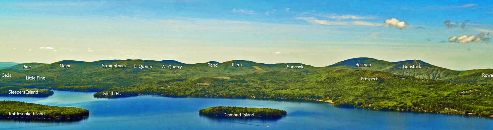
The Belknap Mountain Range is a prominent range west of Lake Winnipesaukee in the towns of Gilford, Gilmanton, and Alton, NH. The range and the county in which it rises were named for Jeremy Belknap (1744-1796), author of the first comprehensive history of New Hampshire and a member of one of the early (1784) scientific expeditions to Mt. Washington (though Belknap himself did not reach the summit). The principal peaks on the main ridge, from north to south, are Mt. Rowe (1,690 ft.), Gunstock Mtn. (2,250 ft.), Belknap Mtn. (2,382 ft .), and Piper Mtn. (2,044 ft.). A fire tower on Belknap and the cleared summit of Gunstock, as well as numerous scattered ledges on all the peaks, provide fine views of Lake Winnipesaukee, the Ossipee and Sandwich ranges, and Mt. Washington. Principal trailheads are located at the Gunstock Mountain Resort (east side) and Belknap Carriage Rd. (west side). The East Gilford Trail also ascends from the east. Paths along the ridge connect all four summits. Mt. Major (1,786 ft.), which has excellent views over Lake Winnipesaukee, is located in Alton, east of the main Belknap Mtns. A long, lumpy ridge runs east from Belknap Mtn. to Mt. Major, consisting of Straightback Mtn. (1,910 ft.) and several other humps that are officially nameless but have been given local names by the Boy Scouts of the Hidden Valley Scout Reservation: Mt. Klem (2,001 ft.), Mt. Mack (1,945 ft.), and Mt. Anna (1,670 ft.). A parallel ridge to the north is sometimes called the Quarry Mountains. The jewel of this range is Round Pond, a beautiful and secluded mountain pond lying at the foot of Mt. Klem, just south of the main ridgecrest, at an elevation of 1,652 ft.
Public and quasi-public organizations own most of the peaks and much of the slopes of the Belknap Mtns. In general, camping and fires are prohibited in this area. The public ownership includes Belknap County (Gunstock Mountain Resort), the State of New Hampshire (Belknap Mountain State Forest), and the Town of Gilford. The Griswold Hidden Valley Scout Reservation, owned by the Daniel Webster Council Boy Scouts of America, includes much of the land to the south of the eastern ridge and a considerable portion of the ridge itself, including most of Round Pond (the western shore is part of Belknap Mountain State Forest) and Mts. Klem, Mack, and Anna. A major network of trails is maintained in the Hidden Valley Scout Reservation, of which the ones on and near the ridgecrest are open to public use. The trails near the main camp area are not open to the general public without advance permission. Although a considerable amount of the Range is in conservation, either public or private, there are still areas within the range that cross private land (See which ones). Please respect the landowner’s rights and use these trails with great care. A volunteer organization, the Belknap Range Trail Tenders (BRATTS), has assumed primary responsibility for the maintenance of many of the trails in the Belknap Range.
For those of you interested in more information on the formation of the Belknap Range read “Stepping-Stones Across New Hampshire: A Geological Story of the Belknap Mountains.” by Jay Long (2005) or Bedrock and Surficial Geology of the Lakes Region of Central New Hampshire by Dan Tinkham and John Brooks.
Hiking conditions in the Belknap Range are updated frequently at www.newenglandtrailconditions.com
________________________________________________________________________________________________________________________________________
Much of this description is excerpted from “Southern New Hampshire Trail Guide. 3rd Edition. 2010. Compiled and Edited by Gene Daniell and Steven D. Smith. Appalachian Mountain Club Books. Boston MA.” to which the reader is referred. Many trail descriptions found on this website are from this AMC trail guide which have resulted from a cooperative effort between the AMC, Hal Graham and others of BRATTs as well as Hidden Valley Scout Camp. Trail descriptions not found in the AMC trail guide have been provided by BRATTS “trail adopters” and others and are so noted.