Click to download trail description.
Trail Name: Red Trail (Mt. Klem-Mt. Mack Loop)
Gilford, NH
Trail Description: Weldon Bosworth, Hal Graham and Southern New Hampshire Trail Guide. 3rd Edition. 2010. Compiled and Edited by Gene Daniell and Steven D. Smith. Appalachian Mountain Club Books. Boston MA.
_______________________________________________________________________________________________
This trail is on the Griswold Scout Reservation but is included here because of its proximity to Round Pond and because of eh various routes to access this loop trail.
Red Trail (Mt. Klem-Mt Mack Loop) – Description
This loop trail, part of which is a segment of the Belknap Range Trail, runs from the shore of Round Pond to a point just east of the summit of Mt. Mack (missing the wooded, viewless summit of Mt. Klem by about 100 yd. and 50 ft. of elevation), then descends back to the shore of Round Pond. It is blazed in red (with one section blazed in red and orange) and is fairly easy to follow, although some care is needed, particularly in the open areas. The loop is described in a clockwise direction.
The northwestern trailhead is on the eastern shore of Round Pond on the Round Pond end of the Round Pond-Piper Link (blazed green). At this junction it is marked with two red wooden diamonds and a sign pointing the way to Mt.Klem. Leaving the shore of Round Pond, the trail climbs steadily through a dense coniferous forest, then levels and passes through a small sag. It then climbs more easily, crossing a stone wall and ascending to a ledgy area where it swings to the left, descending slightly, then ascends slightly across another ledgy outcrop. It now descends slightly through a shallow, flat sag, and runs on contour as it curls around the north end of Mt. Klem at 0.6 mi. with open views to the north and northwest.
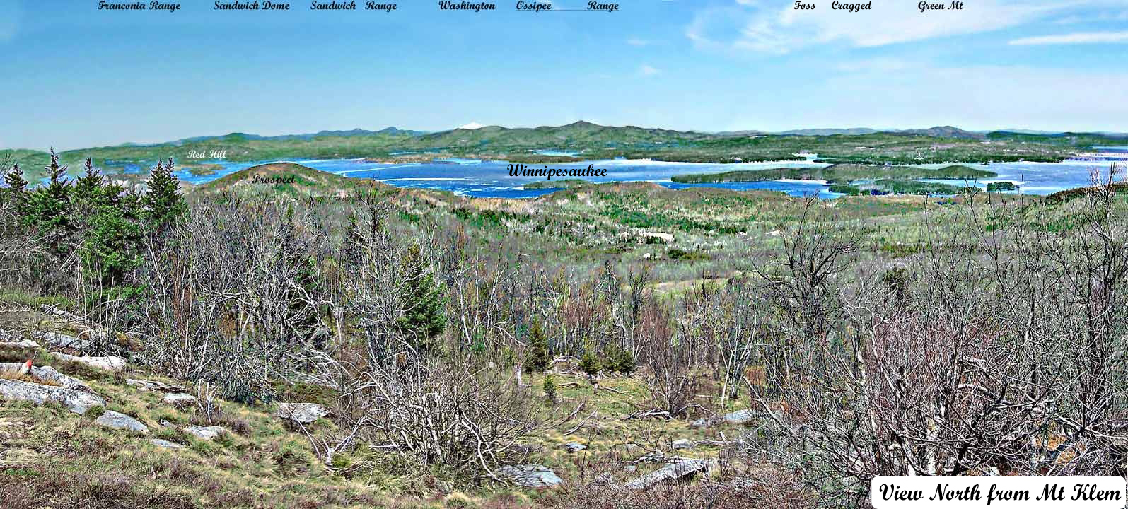
At 0.8 mi. it passes a cleared outlook to the northeast and swings right, then runs almost level for some distance. The trail continues south to the junction with the Dave Robert’s Quarry Trail (blazed white: Sign “Rand”) entering from the east (left) at 0.9 mi. This trail links to Mt.Rand, West Quarry Mt and East Quarry Mt. (and eventually to Mt. Major ) to the east. The true summit of Mt. Klem is about 100 yds west of this junction where there is a marked with a cairn and with an arrow pointing west. Finally it begins to descend and crosses an open area with views at 1.0 mi. It descends across another ledgy spot with a view into a sag at 1.3 mi., then climbs up to a rocky knob, crosses a small dip, and climbs to its southeastern junction with the Belknap Range Trail (blazed red) coming from Mt. Anna at 1.4 mi. near the summit of Mt. Mack. From here it merges with the RoundPond-Mt.MackTrail which is blazed both red and orange and descends along a recently widened logging road to the southeast shore of Round Pond, passing an old communications tower at 1.5 mi. and descending past a ledge 15 yd. left with a wide view south and west at 1.7 mi. and continuing down an eroded pitch, crossing the orange-blazed Mack Ridge Trail at 1.9 mi. (To the left, this trail descends to the Hidden Valley Reservation).
The loop trail descends to another jct. at 2.1 mi., near the shore of Round Pond. Here it turns right (the trail to the left descends to the Hidden Valley Reservation) and the blazing changes back to red. It crosses an inlet brook in 100 yd. and in another 100 yd. enters a small clearing among the pines (a campsite of the Hidden Valley reservation), where the Mack Ridge Trail enters on the right. The loop trail continues ahead, descending gradually to the junction where the loop began.
Distances from Round Pond trailhead (1652′):
-
- to Mt.Klem (2001’): 0.75 mi. (1.2km), 350 ft., 45 min.
- to Mt.Mack summit (1945′): 1.5 mi. (2.4 km.), 550 ft., 1 hr. 15 min.
- to Round Pond (southeast end of loop): 2 mi. (3.2 km.), 2 hrs.